Sunday, February 03, 2008

lights? camera? action?


Well, we will get the flashing lights, but will we get effective enforcement? or what about effective results? Was a baseline speed study conducted so we can have verifiable results that would assist in determing effectiveness? Or is this flashing light a political response to an engineering issue?

The newly installed lights and signs pictured here are at the eastern perimeter of the school zone on Governor's Road, at Huntingwood Dr.
Posted by Picasa

Wednesday, January 16, 2008

half way busing

"a high school student in the public board has to live 3.2 km from school to qualify for busing. In the Catholic board, that distance is 1.6 km"

That's an interesting stat; 1.6 km is not very far to walk. Joint busing is one of the strategies for Governor's Road, but it looks as though this, and many of the ideas to improve traffic, are still a long ways from becoming reality.
Talks stalled on joint school busing policy

The Hamilton Spectator, (Jan 16, 2008)

Talks between Hamilton's public and Catholic board chairs are still stalled over the touchy business of forming a joint agency for busing city students.

Public board chair Judith Bishop said talks haven't gone anywhere on combining Catholic and public bus routes, a plan she says would save taxpayers money.

She said Hamilton is one of only three Ontario school districts without joint busing -- and she says it boils down to the Catholic board using generous busing to draw students, and thus funding, to its schools.

For example, a high school student in the public board has to live 3.2 km from school to quality for busing. In the Catholic board, that distance is 1.6 km.

"The Hamilton-Wentworth District School Board believes in one bus, one policy, one route, and we haven't got anywhere," Bishop said.

"There's a difference in philosophy."

The province wants public and Catholic boards across Ontario to form joint entities to save costs by sharing bus routes and using good routing and management practices.

The Halton public and Catholic school boards this week launched a joint consortium -- not controlled by or located at either board -- with 372 vehicles to transport 25,000 kids to school.

General manager Karen Lacroix said Halton has, since 1996, had joint busing in its public, Catholic and French Catholic boards, predating recent provincial instructions that boards bus together.

This week they launched a new consortium with all four Halton boards -- public, Catholic and two French boards -- with a separate office, phone number and focus on zones, not board districts.

"Any amalgamation has its issues, but the fact that three boards had an integrated transportation service for so many years... made (it) easier than for boards that hadn't been sharing services," Lacroix said.

In Hamilton, no such progress. Bishop said without universal standards for busing, boards differ in their policies. She feels the Hamilton Catholic board is unwilling to give up its generous busing policies, in the interests of saving taxpayer money.

But Hamilton Catholic school board chair Pat Daly denies the stumbling block is about the distance at which students are bused. He says talks never reached that level of detail.

He said it's about governance.

"Just in terms of autonomy and control over policy, that's one of the issues," said Daly. He said he hopes it doesn't come to focus on details like busing distances. "It's important to note that, while we don't have the full consortia in place, we have been co-operating for years (in Flamborough)."

Daly said his board has one of the most efficient bus systems in Ontario and doesn't want to jeopardize that in a joint effort that may not bring savings.

At a provincial level, Catholic trustees have raised concern that a one-policy model may risk Catholic autonomy.

In Halton, however, Lacroix said that the boards have begun to lease a neutral office location and since 1996 have been realizing more than $1 million in annual savings from joint busing.

rfaulkner@thespec.com

905-526-2468

Friday, January 11, 2008

from 50 to 40 in a flash?


Craig Campbell and the Dundas Star continue to provide excellent follow-up reportage on local traffic issues.

Governor's Road awaits safety improvements
Group calls for further safety improvements
Craig Campbell, Dundas Star News, Published on Jan 11, 2008

Long discussed improvements to Governor's Road traffic control should be on their way, as city staff prepare to install a new reduced speed zone along a three school stretch of the road. City of Hamilton traffic technologist Sue Russell couldn't say when the system would be operational, as there may be some bugs to work out.

"It's new equipment and a new program. There could be some unforeseen problems, as with any new product," Ms. Russell said. "I don't want to make any promises I can't keep."

The reduced speed school zone was approved by city council in April 2007. One of eight such school zones across the city, the Governor's Road zone will stretch from Moss Boulevard to 75 metres east of Huntingwood.

Flashing lights will warn drivers the regular 50 km/h speed drops to 40 km/h during morning, mid-day and afternoon rush hours.

The flashing light speed zone will be in effect for just over five hours each day, between 7:50 a.m. and 4 p.m. The part-time school zone was anticipated to be in place by September 2007, when the new Sir William Osler School was scheduled to open. Delays in the school's completion coincided with an apparent delay in receiving equipment from a supplier.

Osler School opened in November 2007 without the school speed zone in place. Ms. Russell said this week an expected start date for the new system is not set. She said staff will need training before the equipment is installed.

The idea of a school speed zone, along with a roundabout on Governor's Road, was raised while former councillor Art Samson represented Dundas. Mr. Samson wanted to see safety improvements made to the less than one kilometre stretch of road that includes St. Bernadette Catholic Elementary School, Highland Secondary School, and Sir William Osler Elementary.

Start times for the schools range from 8:15 a.m. at Highland, to 9 a.m. at St. Bernadette to 9:10 a.m. at Osler.

When the reduced speed zone is operational, it is planned to be in use from 7:50 a.m. to 9:10 a.m., then from 10:59 a.m. to 1:45 p.m., and finally from 2:45 to 4 p.m.

The new elementary school's morning bell time coincides exactly with the end of the morning reduced speed, at which time it will return to 50 km/h from 40 km/h.

Ron Gallo of the city's traffic department said a consultant will be hired to conduct an environmental assessment of a roundabout in area of Governor's Road and Davidson Boulevard.

Mr. Gallo said the budget is in place and he hopes the assessment will be completed in 2008, allowing the design to be done in the first quarter of 2009 and construction by the end of next year.

"That's a best case scenario for me," Mr. Gallo said, noting he'd been involved in discussions about a Governor's Road roundabout for more than two years, and would like to see it done.

Transportation for Liveable Communities sent an e-mail this week to all members of Hamilton's city council, supporting a new reduced speed zone and a roundabout at Davidson Boulevard, along with several other recommendations.

The local pedestrian, cyclist and transit interest group also called for a comprehensive traffic audit of Governor's Road --with results released to the public -- additional school crossing guards, and improved public transit service on Governor's Road. Among the changes supported by TLC are new traffic calming measures - in particular bicycle lanes that were proposed in the city's May 2007 Cycling Network Strategy.

Monday, January 07, 2008

TLC for Governor's Road

Local sustainable transportation activists at Transportation for Liveable Communities have sent a letter to Ward 13/Dundas Councillor Russ Powers regarding Governor's Road - the following is lifted from their letter, dealing with specifics of the suggestions put forward by Powers: for the full letter, go to the TLC site here.

Councillor Powers

Transportation for Liveable Communities

Add an advanced left turn signal to the traffic lights at the Governors Road/Creighton Road intersection for eastbound/westbound traffic along Governors Road.

  • Await result of traffic audit to determine need

  • Immediately change the walk/don't walk signal at Creighton to always go to "walk" on the green signal – currently the "walk" signal only appears after a pedestrian has activated the crossing button. The default is "don't walk" which creates confusion for all users by prioritizing cars over pedestrians, and makes crossing more uncertain, thus more dangerous.

Widen Governors Road to accommodate an identified left turn/holding lane from Creighton Road to at least Davidson Boulevard.

Adding an extra lane makes crossings for pedestrians more difficult and dangerous by increasing crossing distance and adding an extra lane of traffic to contend with. Road widening also contributes to a driving environment that induces speed. Therefore TLC strongly opposes a general widening, but supports limited , site specific widening to create turning lanes if required at St. Bernadette's school, and Highland Secondary school.

Install traffic lights or a roundabout (includes a pedestrian-activated crossing signal) at Davidson Boulevard.

A roundabout is the preferred option for safety and efficiency reasons, which TLC fully supports.

Install a pedestrian-activated crossing signal at the corner of Governors Road/Huntingwood Drive.

TLC supports this as a possible solution, but only in a context of accompanying traffic calming measures such as (but not limited to) a raised crosswalk and a median island. An alternative solution might include another roundabout at this location in the long term.

Post school crossing guards at the Huntingwood, Castlewood/Bridlewood and Davidson pedestrian crossings.

TLC supports

Extend the sidewalk on the north side of Governors Road from Davidson Boulevard to Pirie Drive.

TLC supports

Install a flashing "Speed Reduced to 40 kph" for the area bounded by the east/west boundaries of the three schools. This is programmed to be activated during morning and late afternoon/evening rush hours.

Evidence suggests that signs are not enough to influence driver behaviour, thus TLC supports physical traffic calming measures to slow traffic speeds: examples include lane narrowing, bicycle lanes, wider sidewalks, a traffic median, to enhance safety in the school zone.

Continue to lobby for a crossing guard at the Governors Road/Bridlewood /Castlewood Drive intersection.

TLC supports

Conduct a comprehensive traffic audit to identify contributing factors.

TLC supports, and requests a copy of the final report

Enhance public transit frequency along Governors Road during rush hours on weekdays.

TLC supports, with the following considerations:

  • there is currently no bus service provided on Governor's Road on weekends – adding rush hour buses to alleviate traffic fails to address the demand for transit mobility for residents on weekends. TLC requests weekend bus service for Governor's Road.

  • Current levels of transit service are poor in the entire ward, with one hour wait times much of the day on both Governors, and King..TLC therefore requests a comprehensive review of transit operations in Dundas with the goal of improving the level of service.

Review signal synchronization for eastbound/westbound traffic at Main Street, Oglivie Street and Creighton Road.

TLC supports synchronization that discourages speeding and takes into account the requirements of pedestrians for prompt crossing service.


For all the points noted, TLC requests a full update from the councillor/city of Hamilton on actions taken or decisions made.

Further: since our original letter, the Transportation Master Plan for the city has been approved by council – in that document there are plans specific to the area in question, but not addressed in councillor Powers' initial list of proposed solutions. The TMP refers to bike lanes for Governor's Road "Dundas Street-Governor's Road [from] Cootes Drive [to] Castlewood Blvd BL [2.9km at a cost of $166,750, to be done in the Medium term (http://www.myhamilton.ca/NR/rdonlyres/1ECE9040-72DC-432B-B480-163B810363C0/0/3CyclingNetworkStrategy.pdf ).

Therefore, TLC strongly recommends action on bike lanes be fully integrated with any road work to be done on Governor's Road. Bike lanes would assist in creating safer and more pleasant conditions for pedestrians and help improve the roadside atmosphere while giving more options to sustainable transportation users.

In conclusion, TLC would like to reiterate that users of Governor's Road include cyclists, pedestrians, transit and drivers. The current city wide transportation master plan, and the city's Vision 2020 planning documents all emphasize supporting sustainable modes of transportation. As a result, TLC expects any changes on Governor's Road to reflect this emphasis.

-30-

We'll keep in ear to the ground to see what is in store, and post it here.

Tuesday, November 13, 2007

new school, same road

The Sir William Osler elementary school opened to students today. 640 of them.

No changes to the roadway environment as of yet.

No word on when, or for that matter even if, any changes to improve safety will occur.

Time to start digging...

Here's news from the daily:

A new chapter for students

The Hamilton Spectator

Sir William Osler school offers escarpment views, latest technology

DUNDAS (Nov 13, 2007)

The location was debated for years. Labour spats delayed it for months. But today, Sir William Osler Elementary School will open for Dundas students.

The two-storey school on a steep site on Governor's Road was a buzz of activity yesterday, as staff unpacked boxes, families with jogger strollers took tours, and principal Maria Rowles played hostess in a long-awaited new home.

"We have 640 students. Not only did their moms and dad come, their grandparents came," said Rowles, estimating 1,000 visitors toured the school. The school is named for William Osler, a celebrated physician raised in Dundas.

Its opening was delayed by provincial labour disputes, which kept students in old schools to which they'd already bid farewell. It also created the challenge of moving a school during the year.

"It's a challenge because we're operating the same staff in two sites."

Osler is designed on a template, so it's similar to other new public schools Ray Lewis, Gatestone, Ancaster Meadow and new Lawfield elementary, which opens Monday on the Mountain.

Until now, kids planning to attend Lawfield were at Vern Ames (junior kindergarten to Grade 5) and Seneca (grades 6 to 8). Kids attending Osler were at Central Park (junior kindergarten to Grade 4) and Dundas District (grades 5 to 8), and Dundana students had been at either of the two feeders.

Parent Brian Peirce said his two kids would've liked to finish the school year at Central Park and Dundas District, rather than move to Osler mid-year. He adds the new school is "beautiful" on a site that had been a rolling, sparsely wooded area with soccer fields.

"It's been long, but it's here," said parent Eva Fisher, who thinks Osler's 9:10 a.m. start will create traffic chaos because it's too close to bell times at Highland secondary and St. Bernadette Catholic elementary, both on the same side of Governor's Road as Osler.

A parent survey narrowly chose the 9:10 a.m. start time at Osler. Rowles said parents were split: those with young kids worried an early start would be hard to accomplish, while parents of upper-year kids wanted an early start to leave time for after-school activities.

The school is a piece of work: extra-wide lockers to share; light streaming in from floor-to-ceiling windows; learning "pods" outside classrooms; a gym some colleges would dream of.

Richard Francki, senior manager of facilities, said the $10-million school lets the board close two others, so it saves on energy, transportation and staffing.

With room for 667 students, it doesn't yet have portables. New schools also avoid lead paint, asbestos, and hot summer days without air-conditioning, which make school less appealing.

And with stunning views of the Escarpment and rolling yards that made stormwater diversion crucial, it looks like tobogganing is a real possibly.

Dundas trustee Jessica Brennan said one argument in favour of using the proposed Veterans Park site was that it was flatter, so grading wouldn't add to the cost. Still, she said she was thrilled to finally open the doors.

Rowles, who is proud of the school's escarpment views, notes she has also been able to buy 21st century tools for the new building. It has nine SMART Boards and nine other screens that function like an interactive digital update on the classic chalkboard.


See a slide show presentation of the new Sir William Osler Elementary School.
For more go to thespec.com

Monday, June 25, 2007

From Councillor's Web Site

I found this on the ward councillor's web site:

"Governor's Road Concerns

Governor's Road from Main Street, westbound to Ogilvie Street:

1. Widen two bridges crossing Spencer Creek and intersection at Governors Road/Oglivie Street to accommodate one additional lane (use to be determined).
2. Add a 4 way, advanced left turn signal to the traffic lights at the Governors Road/Oglivie Street intersection.

Governor's Road from Ogilvie Street, westbound to Creighton Road:

1. Currently there are two westbound and one eastbound lanes on Governors Road...identify the middle lane as an additional eastbound lane during the morning rush hour and an additional westbound lane during the late afternoon/evening rush hour.
2. Investigate the possible need for traffic lights or a pedestrian-activated crosswalk at the Governors Road/Overfield Street intersection.


Governor's Road from Creighton Road, westbound to Pirie/Wainwright Drive:

1. Add an advanced left turn signal to the traffic lights at the Governors Road/Creighton Road intersection for eastbound/westbound traffic along Governors Road.
2. Widen Governors Road to accommodate an identified left turn/holding lane from Creighton Road to at least Davidson Boulevard.
3. Install traffic lights or a roundabout (includes a pedestrian-activated crossing signal) at Davidson Boulevard.
4. Install a pedestrian-activated crossing signal at the corner of Governors Road/Huntingwood Drive.
5. Post school crossing guards at the Huntingwood, Castlewood/Bridlewood and Davidson pedestrian crossings.
6. Extend the sidewalk on the north side of Governors Road from Davidson Boulevard to Pirie Drive.
7. Install a flashing “Speed Reduced to 40 kph” for the area bounded by the east/west boundaries of the three schools. This is programmed to be activated during morning and late afternoon/evening rush hours.
8. Continue to lobby for a crossing guard at the Governors Road/Bridlewood /Castlewood Drive intersection.

General:

1. Conduct a comprehensive traffic audit to identify contributing factors.
2. Enhance public transit frequency along Governors Road during rush hours on weekdays.
3. Review signal synchronization for eastbound/westbound traffic at Main Street, Oglivie Street and Creighton Road.
4. Perhaps the school boards could review their starting/finishing times to reduce pedestrian traffic during rush hour (maybe stagger the starting/finishing times amongst the three schools to lessen the focused impact time slot).
5. Perhaps the School Boards should rationalize their individual busing services and possibly consider merging into a single provider…this may actually reduce the number of buses on the road with a corresponding reduction in operating costs.. "

[end of quoted text]
OK, some nifty ideas, but the overall thrust is dealing with automotive traffic efficiency, and very little to address pedestrians and cyclists concerns.

While most of the above ideas are acceptable, there are a couple of big bad ideas that stand out - like number 2 under" Governor's Road from Creighton Road, westbound to Pirie/Wainwright Drive:" widening Governor's Road?! Perhaps middle turn lanes at school entrances, but the entire length of Governor's? This type of engineering would induce traffic speeds and make the crossing wider for pedestrians.

Besides, there is no mention of bicycle lanes, although the city's transportation master plan has Governor's Road marked for them along the entire stretch. There's not a lot of room for widening, so the extra traffic lane would likely be at the expense of cycling lanes. Rather than traffic calming by lane narrowing and providing a buffer between cars and pedestrians by providing space for cyclists, road widening just makes it more dangerous for every user.

While this is about a kilometer west of the area we have been dealing with, the bridge widenings at Ogilvie and Governors fail to mention the need for wider sidewalks, the current sidewalks are horribly narrow on Governors, and only on one side of Ogilvie.

And why aren't we talking about traffic calming here? Think boldly: eliminate one bridge (on Ogilvie, north of Governors) and open Spencer creek to view (currently encumbered with bridges and sewer pipes): it would certainly make the intersection more beautiful, not to mention safer (drivers have alternative options a half block away at Main.)

As far as increased transit, there is a need for transit on weekends (there is currently no weekend service, meaning the nearest bus stop on weekends is at least one kilometer away, more like three for others on this route.)

So clearly there is room for improvement on this list of suggestions. I don't know how or when the list got made, but there it is. I certainly wasn't consulted, as the councillor suggested in a previous newspaper column, nor to my knowledge was Transportation for Liveable Communities (TLC) approached, though they sent a letter on the topic to the councillor December 2006.

Sunday, April 01, 2007

Roundabout

Watch a live cam of the Ancaster Traffic Circle (in the city of Hamilton) - a similar roundabout is proposed for Governors Road at Huntingwood, which would be an effective way to calm traffic.

I'm fairly certain that the city has budgeted some money to bring this into reality.

It's "new" so it will likely frighten people at first, but it is actually safer in terms of lower collision rates, etc. than other intersection types.

Saturday, March 31, 2007

Lay of the land

A view of Governors Road at the start of the eastern section that this web site is concerned with. Looking west from Creighton (the signalized intersection in the photo, above) the three schools are on the left (or south) side of the street in this order (starting at the crest of the hill): St. Bernadettes Elementary, Highland Secondary, and the new school, now named Sir William Osler elementary.

Governors is a straight road in this section which does little to deter speeding, with pedestrian crossings aproximately one kilometer apart (here, at Creighton) and at the next signalized intersection at Castlewood (below, viewed facing the site of the new school):


Another view, this time looking east down Governors from Castlewood (photo taken from the crosswalk):


I include this photo (below) of an intersection in between the two signalized intersections to show the kind of engineering that is pro-car at the expense of pedestrians. The rounded corner makes it easy for high speed turns, whereas pedestrians have a wider span to cross (in the path of those fast cornering vehicles) - this kind of engineering should be altered to become more of a "corner" rather than an "off-ramp."


Check back for updates as we continue to monitor the situation.

Thursday, March 08, 2007

LITTLE BIT, WEST


A little bit west of Dundas, in Westdale, there have been a few minor traffic calming elements installed. This is one of them, a little traffic island on Forsyth. This is the kind of thing (pretty much) we're looking for on Governor's. (Better if it were a raised median though). Well done Ward One! More from that ward later...

Sunday, January 28, 2007

Paper Powers

It's not much information, but the following appeared in this week's Dundas Star News, in Councillor Russ Powers' monthly column:

Any users of Governor's Road are well aware of the sometime challenges of that route. This year, a detailed study of all aspects of this transportation link will be conducted. Your participation will be solicited and very much appreciated as the decisions reached will determine how things are improved.
Users of Governor's Road include cyclists, pedestrians, transit and drivers. The current city wide transportation master plan, and the city's Vision 2020 planning documents talk about supporting sustainable modes of transportation. How hard will it be to see that Governor's Road gets the "balanced" approach so desperately required to make it a safe road for all users?


Friday, January 19, 2007

Letter for Liveable Community

PO Box 19, 1280 Main Street West, Hamilton ON L8S 1C0
tlchamilton.blogspot.com
g-tlc@mcmaster.ca
905-525-9140 ext. 26026

Monday, December 18, 2006


Dear Councillor Powers,

Transportation for Liveable Communities (TLC) is a working group of the Ontario Public Interest Research Group (OPIRG) McMaster. TLC works to achieve balanced sustainable transportation solutions in the city of Hamilton.

We are writing to draw attention to the traffic situation on Governor’s Road in Dundas.

With the new Dundas West elementary school under construction on Governors Road at Bridlewood, there will be three schools (including Highland Secondary School and St. Bernadette’s elementary school) on this short stretch of highway (less than 1km).

The statement of a problem can make all the difference when seeking solutions. TLC is concerned that a solution you offered on your web site during the recent election campaign begins with the assumption that “traffic flow” is the problem on Governor’s Road, and offers road widening as a solution.

TLC feels that this is the wrong assumption and a desperately wrong conclusion.

The problem, as we see it, is traffic flows all too well the majority of the time on Governor’s, and that the speed of that flow puts school children and other pedestrians, cyclists and drivers at risk.

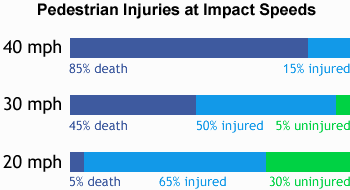
As you are likely aware there is a direct correlation between traffic speed and pedestrian fatalities:

Fig. 1 U.K. Department of Transportation, 1987. Killing Speed and Saving Lives, London, UK DOT.

Generally the only time traffic slows down on Governors is during “rush” hours, when the presence of too many single occupancy vehicles all going in the same direction at the same time creates a situation that is, from a pedestrian and cycling point of view, actually safer in terms of collision impacts. We should be aiming for a 30km/h maximum speed limit in the school zone.

TLC would thus prefer to pose the question: “what measures can be employed to create a safe and healthy environment for children using active methods of getting to school (i.e. cycling, walking) and to engineer a safer roadside environment for area residents outside of school hours?”

The City of Hamilton’s Public Health department recognizes the need for safe routes to school:

“Concerns about health and pedestrian safety among our children and air quality issues are prompting us to rethink the way we choose to get around in our communities,” said Sue Connell, Public Health Nurse with the City of Hamilton. “Obesity and inactivity in young children are reaching unprecedented levels and are creating serious health problems in our children. Vehicle transportation contributes to air pollution and smog and our children are especially vulnerable to the impacts of poor air quality. Many of the school zones in the Hamilton area are unsafe because of traffic concerns because large numbers of children are being transported to and from school. By walking to school with their parents or caregivers, children have an excellent opportunity to learn and develop their pedestrian skills.”

newsandpublications/newsreleases/ 2005news/september/05-09-30.htm

Road widening would only allow for increased vehicle speeds and make crossings more dangerous than the current situation, and run counter to the goals of the Transportation Master Plan currently under consideration by the city, and the goals outlined in Vision 2020:
  • To develop an integrated sustainable transportation system for people, goods and services which is environmentally friendly, affordable, efficient, convenient, safe and accessible.
  • To encourage a shift in personal lifestyle and behaviour towards transportation choices that enhance personal health and fitness, save money, and have the lowest environmental cost.

It is imperative that we get the necessary improvements in place as opportunity presents itself. And it is important that proper engineering is applied to ensure safe outcomes.

When slowing or ‘calming’ traffic, the right design invites the right driver response. The guiding principle of traffic calming is to influence motorist speeds and behavior through good design whenever possible, rather than by traffic control measures such as traffic signals and STOP signs.

There are many design and engineering tools that can be used to slow down traffic and make it safer for children to walk and bicycle to school including;
  • Narrow lanes
  • Chokers and chicanes
  • Speed humps
  • Raised pedestrian crosswalks
  • Neighborhood traffic circles
  • Reduced corner radiiSpeed sensitive signals
Source: http://www.saferoutesinfo.org/guide/engineering/slowing_down_traffic.cfm

Proper consideration must be given to effective traffic calming design if we are to be supportive of active modes of transportation like walking and cycling. Lane narrowing, the addition of bicycle lanes, wider sidewalks, a traffic median, a pedestrian crossing are all potential treatments that could enhance the safety of the school zone.

Surely the concentration of schools on this dangerous roadway makes safety considerations a priority for the city to address in a timely fashion.

TLC is happy to assist by being part of a public process that effectively deals with the worthy goals of providing safe and active routes to school, and improved cycling and walking facilities for area residents.

TLC would appreciate your prompt response and an outline/timeline of the next steps you intend to take.

We look forward to hearing from you in the near future.


Randy Kay

For Transportation for Liveable Communities

Friday, December 22, 2006

1812 military road


One need not search long to find reference to August 8, 1812, "General Brock marched through the valley, and out the Governor’s Road with forty regulars and 260 militia men....After picking up sixty Indians at the Mohawk Village" they went on to capture Detroit a few days later, a key victory for the vastly outnumbered force. (Woodhouse, T. Roy. Dundas Historical Society, The History of the Town of Dundas, Part 1, p23)

"Following their defeat by the Americans at the Battle of Moraviantown near the Thames River, the British and allied warriors of 1813 under the Shawnee Chief Tecumseh (who died in this battle) travelled east to the Grand River by trail and onto Lake Ontario via the Dundas portage, ultimately camping at the ‘fine large sandy bay’ at Burlington Bay." (Henderson, Bob, Every Trail Has A Story, p84)

Saturday, December 16, 2006

Distance Map

According to my mapquest data, (after finding the km button, rather than the miles) we can see that the stretch of road this blog is primarily concerned with is less than 1 kilometre in length. But an important .7km given the location of three schools (two primary and one secondary school) along this corridor.

Friday, December 15, 2006

PETITION

Hi - you can print off a legal size pdf version of the new Governor's Road Safety Petition by following the link. The text of the petition is copied below:

~

Whereas new elementary school construction on Governors Road will result in more children crossing or walking adjacent to Governors Road, and,

Whereas upon completion of the new school there will be two elementary schools and one high school on this short stretch of road, and,

Whereas children should have safe and active routes to school in order to gain emotional and physical benefits of a healthy lifestyle, and,

Whereas there is no pedestrian crossing point between Bridlewood and Creighton, and,

Whereas there is a direct relationship between vehicle speed and pedestrian fatality, and,

Whereas an engineered traffic calming solution is preferable and more effective than signs or flashing lights, and,

Whereas a city Transportation Master Plan study identifies Governors Road between Creighton and Bridlewood as a suitable location for bicycle lanes, and,

Whereas Governors Road is a historical roadway, being the first non aboriginal road constructed in Upper Canada,

We (the undersigned) request that the City of Hamilton take immediate steps to ensure safe driving, cycling and walking conditions on Governor’s Road, between Creighton and Bridlewood above and beyond posted crossing guards, flashing lights and signed school zone by,

  • instituting physical traffic calming measures to effectively reduce the incidence of speeding vehicles i.e traffic medians, narrow lanes, roundabouts, as deemed appropriate to calm traffic
  • initiate an Environmental Assessment process if required to make changes to the roadway in keeping with traffic calming goals
  • install proper bicycle lane facilities and wide sidewalks to encourage active and safe routes to school
  • create a pedestrian crossing at or near Governors and Huntingwood
  • plant native vegetation on both sides of Governors Road where feasible to help create a comfortable pedestrian environment
  • install an attractive gateway feature that pays homage to the historical significance of the road and alerts drivers to the school zone

Thursday, November 23, 2006

The Hollingsworth Thread

Sorry to take so long to get back to you on this. The following is the most up to date information I could get for your questions:
1.We understand that as a condition of development approval, the School Board will be required to construct a westbound left turn lane on Governors Road for the access into the School site.
2. We understand that the City included the Class EA Study for the feasibility of constructing a roundabout at Governors and Davidson into the 2007 Work Plan.
3. The implementation of the bicycle lanes on Governors Road, as proposed in the City Wide Transportation Master Plan (TMP), will be considered in all future work. However, since the TMP has not been approved yet by Council, bike lanes cannot be installed as part of the current work.
Hopefully this answers your questions. If you have any other questions, please do not hesitate to call or e-mail.

Brian Hollingworth
Associate Director
IBI Group
230 Richmond Street W, 5th Fl.
Toronto, Ontario, M5V 1V6
Tel: 416-596-1930 ext. 414
Fax: 416-596-0644

-----Original Message-----
From: randy opirg [mailto:randy@opirg.org]
Sent: November 2, 2006 4:02 PM
To: bholling@ibigroup.com
Subject: Re: Governors Road

I appreciate the note Brian - I was about to give up hope! The particular section of Governors Road I am referring to is essentially west from Creighton. The PIC/GRIDS maps showed a blue line which indicated bicycle improvements.
Thanks for your time on this,
Randy
----- Original Message -----
Sent: Thursday, November 02, 2006 2:48 PM
Subject: RE: Governors Road

Just to let you know we have not forgotten your question. I am trying to get more information on the current proposal you are referring to.
Thanks you for your inquiry.

Brian Hollingworth
Associate Director
IBI Group
230 Richmond Street W, 5th Fl.
Toronto, Ontario, M5V 1V6
Tel: 416-596-1930 ext. 414
Fax: 416-596-0644

-----Original Message-----
From: randy opirg [mailto:randy@opirg.org]
Sent: October 13, 2006 1:39 PM
To: bhollingworth@ibigroup.com; htanguay@hamilton.ca
Subject: Governors Road

Hello Hélène and Brian - I attended to PIC for the transportation plan and like the general direction it is going.
When it comes to specifics I have a question in relation to Governor's Road in Dundas - the material I saw showed that there was to be improvements to cycling - either bike lanes, paved shoulder or something. My question is: will these improvements be integrated with the very current work that is being proposed for this stretch of road: I am referring to the Dundas West School and the proposed roundabout (and other traffic calming measures).
This would seem to offer an opportunity to make changes that would enhance the safety of students using the schools, while advancing the TMP goals.
Your thoughts would be appreciated,
Randy Kay
249 Governor's Road,
Dundas ON

Tuesday, November 07, 2006

Contact Catch Up

I spoke with both Kathryn Starodub, Principal of Highland Secondary and Sherri Michell of the Highland Parents Association on Monday October 23, 2006 about Governor's Road.

Kathryn informed me that
  • they had the HSR bus stop across the road from the school moved to the nearby signalized intersection at Bridlewood. Before the move, the location of the stop encouraged students to cross with no infrastructure.
  • She thought flashing lights indicating school zone would be helpful.
  • She indicated that a turning lane at Highland would help relieve traffic tie-ups
  • she felt the timing of the stoplights at Bridlewood/Castlewood and Governors needed to increase the turning times for cars coming onto Governors.
  • The student hit by a car on Governors is back at school and making a great recovery

Sherri emphasised education for drivers, including parents and residents, to remind them to slow down in the vicinity of the school. She questioned the utility of the roundabout, thinking it was too far from the school zone.

OUTSTANDING:

My October 6/06 e-mail and follow up e-mail October 20 still awaits replies from City Staff including: Ed Switenky eswitenk@hamilton.ca, Acting Manager, Traffic Engineering and Operations; Hart Solomon hsolomon@hamilton.ca; Ron Gallo rgallo@hamilton.ca, Supervisor of Signals and Systems, Public Works; and, Rodney Aitchison raitchis@hamilton.ca

Brian Hollingsworth e-mailed to say he was going to provide some info regarding the GRIDS plan for bicycle infrastructure on Governors west of Creighton.

Tuesday, October 24, 2006

coasting

Still waiting for return calls/e-mails from city staff.

I have some updates on converstations with folks from Highland Secondary School, which I will post soon, as well as some new photos of the roadway.

I think rather than try and make all the suggestions about what needs to happen, I will coast a bit (like these local cyclists on Governors) while waiting to hear from city staff about what they think will make things safer for kids on this stretch of road.

Shouldn't that be their job? (and why we need to make sure it happens?)

Monday, October 23, 2006

one minute map


The key stretch of road linking three schools is, according to mapquest, less than a one minute drive.
When we think in terms of slowing traffic through this school zone, we should keep in mind the trade off between speed and safety.
Slowing things a little can mean a lot for children and others crossing this road.

contact 3

Phone tag finally concluded today between St. Bernadette's principal and I: point form notes:
  • large percentage "about 90%" of children are bussed to the school
  • only a few students walk
  • they use the crossing guard at Creighton/Governors
  • it would be useful to have a pedestrian activated signal/crossing between Highland School and St. Bernadettes (there is a long stretch with no crossings between Bridlewood and Creighton)
  • she hasn't spoken to the city about traffic - her concern "is in our driveway, not a lot of our kids go beyond the driveway.")

Other contact - I left another voice mail for the principal at Highland seeking info about their plans, and for a contact number for the Parent's Council.

Councillor Samson's office replied to my prompt for a response from city staff about my earlier questions, so I expect something in the near future.

Saturday, October 21, 2006

front page

School safety, closures will top new councillor agenda: Samson
Craig Campbell, Dundas Star News (Oct 20, 2006)


Two key issues that will face Dundas' new city councillor after the Nov. 13 municipal election are safety on Governor's Road and the role of community councils.

....

This week, outgoing councillor Art Samson suggested to the Dundas Star News that dealing with Governor's Road traffic and safety, doing a better job getting public input on two upcoming school closures and the ongoing Dundas Driving Park master plan are three key issues that will affect the community over the next few years.

Mr. Samson said he has started the ball rolling for a review of crossing guards near a new school planned for Governor's Road, an environmental assessment for a possible roundabout at Davidson Boulevard or Pirie Drive and a study for a possible school speed zone. But if any of those things actually succeed, it will have to happen during the next councillor's term.

And all four candidates say they've heard about it from residents.

Peggy Chapman believes badly planned housing development around Governor's Road is to blame.

And Davidson Boulevard as the only way out of a large neighbourhood causes traffic problems.

"If we're going to build, let's grow smart. I'm big on smart development," Ms. Chapman said. "Maybe there could be another artery or road out of there." [um, roads are the problem, not the solution here]

Ms. Chapman said local residents aren't getting much help from city hall, but she thinks bad development in the area can still be stopped.

"Let's not make mistakes if we don't have to. Let's build it smart," she said.

Keith Sharp said a pedestrian-controlled stoplight has been suggested for a Governor's Road crossing, but he thinks that would just cause more problems.

"There's no easy solution," Mr. Sharp said. "The traffic specialists need to look at it." [yes, and talk to the community about it so we don't get left out of the decision-making process]

Russ Powers said while he was on city council prior to his federal stint, he submitted a plan for improvements to Governor's Road.

"It's my intention to continue to press for that," Mr. Powers said. [Are we supposed to know his plans? I just sent an e-mail to his campaign asking to see what he is proposing ]

Julia Kollek said she asked city staff about building a covered pedestrian bridge that would carry students across Governor's Road and into the new elementary school.

She was told that would cost about $300,000, but Ms. Kollek thinks a cost-benefit analysis - comparing the bridge to the cost to bus hundreds of students for years - should be done before discounting the idea. [human nature - people won't use it, they'll find the shortest most direct route - slow traffic first with some proper engineering moves]

Ms. Kollek also suggested shuttle buses could be used to carry students from specific drop-off points, eliminating some parent's cars from the busy thoroughfare. [how about improved transit routing and bus passes for students?]

....